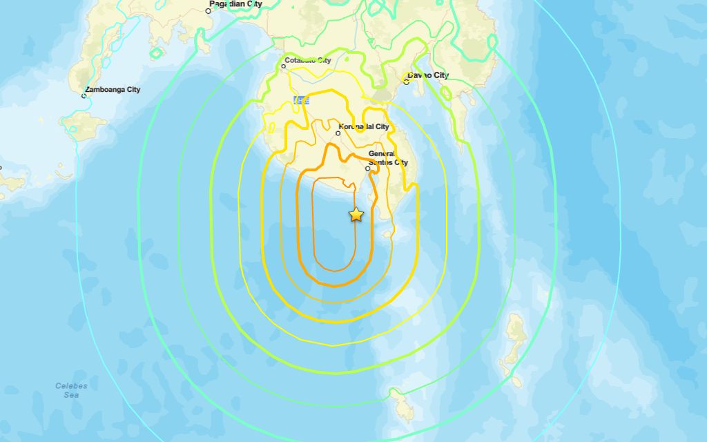
A 7.8 magnitude quake occurred near Kablalan on Sunday morning, according to the U.S. Geological Survey.
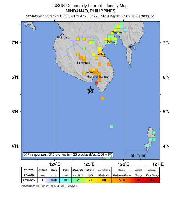
The USGS reported a tremor in the region at 23:37 UTC (07:37 local time). The epicenter was roughly 24 km southwest of Kablalan, at a depth of 57 km.
Did you feel it?
If you noticed the earthquake, you can submit a report through the USGS Felt Report form. The agency has received 347 responses on its online form so far, from people saying they experienced severe to violent shaking. The USGS DYFI report indicates that residents in cities such as Ternate, Tomohon and Manado felt the quake.
Impact and estimated losses
Orange alert for shaking-related fatalities and economic losses. Significant casualties and damage are likely and the disaster is potentially widespread. Past orange alerts have required a regional or national level response Estimated economic losses are less than 1% of GDP of Philippines. Recent earthquakes in this area have caused secondary hazards such as tsunamis and landslides that might have contributed to losses.
Structure information summary
Overall, the population in this region resides in structures that are a mix of vulnerable and earthquake resistant construction. The predominant vulnerable building types are reinforced concrete and heavy wood frame construction.
Detailed tectonic summary
The June 7, 2026, M 7.8 earthquake south of the island of Mindanao, Philippines, resulted from thrust faulting. The earthquake’s depth and moment‑tensor estimate indicate the event occurred within the complex zone of active deformation associated with westward subduction of the Philippine plate beneath the Sunda plate. Northeastern Indonesia and southern Philippines are characterized by complex tectonics in which motions of numerous small plates accommodate the large-scale convergence between the Philippine Sea and Sunda plates. At the location of this earthquake, the Philippines plate is moving towards the Sunda at 7.3 cm/yr.
While commonly plotted as points on maps, earthquakes of this size are more appropriately described as slip distributed over a broad fault area. Thrust faulting events of the size of the June 7 earthquake are typically about 120 x 50 km in size (length x width).
The region around this earthquake is tectonically active and large earthquakes are common. Since 1900, 35 earthquakes with a magnitude of M 7+ have occurred within 300 km of this event. The largest was a magnitude 8.3 earthquake on August 15th, 1918 that occurred 118 km to the west. More recently, a magnitude 7.4 event occurred on October 10, 2025, 260 km to the northeast, resulting in more than ten fatalities.
Source: The U.S. Geological Survey