A 7.4 magnitude quake occurred close to Bitung on Wednesday morning, according to the U.S. Geological Survey.
The tremor, which hit the area at 22:48 UTC (07:48 local time), was centered roughly 129 km east-southeast of Bitung. It occurred at a depth of 35 km. Seismologists first reported it as a 7.8 event, but later downgraded it to 7.4.
Did you feel it?
If you noticed the earthquake, you can share your experience using the USGS Felt Report form. The agency has so far received 59 reports via its online form from people who report they experienced severe to violent shaking. The USGS DYFI report shows that residents in a few cities, including Katangawan and Manado, felt the quake.
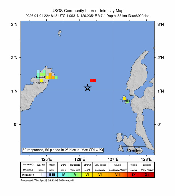
Impact and estimated losses
The USGS categorized this as a Green Alert, which means there is a low likelihood of casualties and damage. Recent earthquakes in this area have caused secondary hazards such as tsunamis that might have contributed to losses.
Structure information summary
Overall, the population in this region resides in structures that are vulnerable to earthquake shaking, though resistant structures exist. The predominant vulnerable building types are unreinforced brick with concrete floor and precast concrete frame with wall construction.
Detailed tectonic summary
The April 1, 2026, M 7.4 earthquake west-northwest of Kota Ternate, Indonesia, occurred at a depth of ~35 km on or near the interface between the subducted Halmahera slab and the overlying Sunda plate, in the complex plate boundary region of eastern Indonesia, about 300 km to the west of the major plate boundary between the Sunda and Pacific plates. Faulting mechanism solutions for the event indicate that it activated a reverse faulting structure, with a moderate dip towards either the northwest or the southeast, in line with the general trend of earthquakes in the region. Though the earthquake occurred near the boundary between the Halmahera slab and the Sunda plate, this earthquake is not a traditional plate interface event such as those experienced in other subduction zones, since the Halmahera slab is completely subducted and has no surface expression. Slip on a fault aligned with either nodal plane is thus consistent with the tectonic setting of this event.
Tectonics in eastern Indonesia are extremely complex and are dominated by the mostly convergent interactions of the Pacific, Australia, Philippine Sea, and Sunda plates, with some authors labeling the most proximate edge of the Pacific plate here as a separate tectonic block called the Caroline plate. The edges of the Sunda and Australia plates are also often subdivided into smaller tectonic blocks, including the Molucca Sea and Birds Head microplates immediately to the south and east of the April 2026 earthquake, respectively. In this context, the April 2026 event most closely aligns with the boundary between the broader Sunda plate and the Birds Head microplate. At depth beneath this earthquake and the Molucca Sea in general, the inverted-U-shaped Halmahera plate, which has no surface expression, also plays a role in regional tectonics. At the location of the April 1st earthquake, the Sunda and Philippine Sea plates are converging in an east-west direction at a rate of approximately 100 mm/yr.
While commonly plotted as points on maps, earthquakes of this size are more appropriately described as slip over a larger fault area. Reverse faulting events of the size of the April 1, 2026, earthquake are typically about 70 km by 35 km in size (length x width).
This area of the Molucca Sea frequently hosts moderate to large earthquakes; in the past 50 years, nine other M 7+ earthquakes have occurred within 250 km of the April 1, 2026, earthquake. This includes a M 7.5 event in January 2007 located only 13 km SW of this event. Despite the large number of events in the region, few have been damaging because of their oceanic setting, though the 2007 event previously mentioned did result in 3 shaking related fatalities and minor damage on the nearby island of Sulawesi.
Source: The U.S. Geological Survey