Article first published: Tuesday, Sept. 1, 2026, 4 a.m. ET
Article last updated: Tuesday, Sept. 1, 2026, 4 p.m. ET
System type: Tropical storm
System name: Edouard
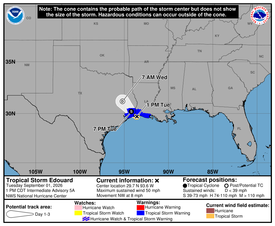
According to the National Hurricane Center’s 4 p.m. Tuesday advisory, Edouard after first crossing the Gulf of Mexico, traveled through Louisiana and is advancing to Texas. Tropical Storm Edouard is 40 miles west of Cameron, Louisiana and 5 miles west of Port Arthur, Texas. The system, with maximum sustained winds of 50 mph, is moving to the northwest at 7 mph.
“… the center of Edouard will continue moving inland over eastern Texas through Wednesday,” forecasters noted. They also said “Continued weakening is expected during the next day or so, and Edouard is forecast to weaken to a tropical depression tonight and dissipate by Wednesday night.”
Yesterday (Monday)
The National Hurricane Center issued the first advisory for a potential tropical cyclone at 10 am yesterday (Monday).
The system had transformed into a tropical depression and was officially named Tropical Storm Edouard. It was later upgraded to a tropical storm with sustained winds of 50 mph. Yesterday’s 7 p.m. report was the first to confirm the system’s new name.
Changes with this advisory
The Tropical Storm Warning east of the Vermilion/Cameron Parish Line in Louisiana has been discontinued.
Warning currently in effect
Tropical Storm Warning for Port Bolivar, Texas to the Vermilion/Cameron Parish Line
Meaning of the warning
A Tropical Storm Warning means that tropical storm conditions are expected somewhere within the warning area.
Hazards affecting land
Wind. Tropical storm conditions are ongoing across portions of the warning area along the northwestern Gulf Coast.
Storm surge. The combination of storm surge and tide will cause normally dry areas near the coast to be flooded by rising waters moving inland from the shoreline. The water could reach the following heights above ground somewhere in the indicated areas if the peak surge occurs at the time of high tide…
High Island, TX to Vermilion/Cameron Parish Line, LA…1-3 ft
The deepest water will occur along the immediate coast near and to the right of the center. Surge-related flooding depends on the relative timing of the surge and the tidal cycle, and can vary greatly over short distances.
For a complete depiction of areas at risk of storm surge inundation, please see the National Weather Service Peak Storm Surge Graphic, available at hurricanes.gov/graphics_at5.shtml?peakSurge.
Rainfall. Edouard is expected to produce rainfall totals of 3 to 7 inches with maximum totals up to 12 inches for parts of the Upper Texas Coast inland through east-central Texas, with potential for 2 to 4 inches in far southwest Louisiana. This rainfall is likely to produce flash flooding, especially in low-lying and urban areas. Significant flash flooding is possible. River flooding may also be possible.
For a complete forecast of rainfall associated with Edouard, please see the National Weather Service Storm Total Rainfall Graphic available at hurricanes.gov/graphics_at5.shtml?rainqpf and the Flash Flood Risk graphic at hurricanes.gov/graphics_at5.shtml?ero.
Tornadoes. A tornado or two is possible through this evening across parts of southwest Louisiana and southeast Texas.
Source: National Hurricane Center