Article first published: Sunday, Oct. 11, 2026, 4 a.m. ET
System type: Post-tropical cyclone
System name: Isaias
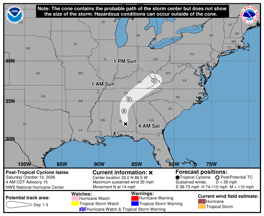
At 4 a.m. Sunday, the National Hurricane Center issued its first advisory of the day for the system, stating that Post Tropical Cyclone Isaias is 65 miles southeast of Nashville Tennessee and 70 miles northeast of Huntsville, Alabama. The system, with maximum sustained winds of 25 mph, is moving northeast at 23 mph.
“Little change in strength is forecast during the next 24 hours,” meteorologists noted.
Yesterday (Saturday)
Isaias traveled through Alabama and advanced to Tennessee.
Hazards affecting land
Rainfall. Rainfall totals of 1 to 3 inches with localized maximum amounts of 5 inches are possible across the Central Appalachians into the Mid-Atlantic. Rainfall totals of 1 inch possible along coastal sections of North Carolina. .
Isolated flash, urban flooding possible across the Central Appalachians and Mid-Atlantic. Significant river flooding across the western Florida Panhandle will crest on Sunday.
For a complete forecast of rainfall associated with Isaias, please see the National Weather Service Storm Total Rainfall Graphic available at hurricanes.gov/graphics_at4.shtml?rainqpf and the Flash Flood Risk graphic at hurricanes.gov/graphics_at4.shtml?ero.
For a list of rainfall observations (and wind reports) associated with Isaias, see the companion storm summary at WBCSCCNS4 with the WMO header ACUS44 KWBC or at the following link: www.wpc.ncep.noaa.gov/discussions/nfdscc4.html.
Tornadoes. A couple of tornadoes are possible today across the Piedmont and Coastal Plain of Virginia and North Carolina.
Wind. Strong wind gusts continue to pose a threat across the southeastern United States today, particularly near the Southern Appalachians. Scattered power outages and downed trees and power lines may occur, with the risk highest in elevated terrain.
Surf. Swells from Isaias will continue to affect much of the Gulf and Southeast coasts of the United States, Mexico, and western Cuba this weekend. These swells are likely to cause life-threatening surf and rip current conditions.
A depiction of rip current risk for the United States can be found at: hurricanes.gov/graphics_at4.shtml?ripCurrents
Source: National Hurricane Center