Article published: Tuesday, Oct. 6, 2026, 4 p.m. ET
System type: Tropical depression
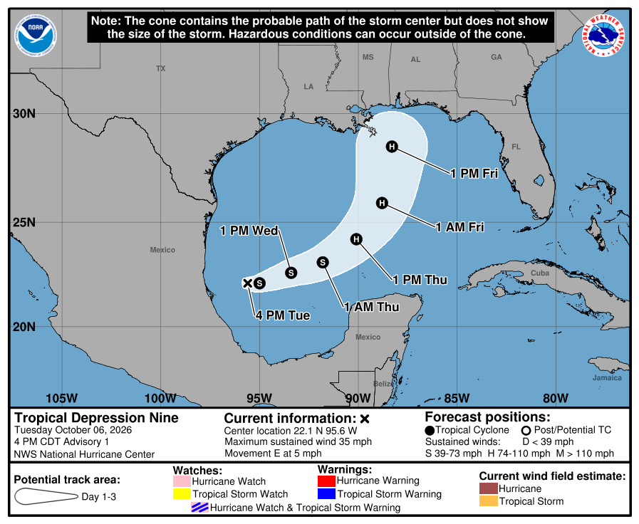
The National Hurricane Center released its first advisory for the tropical depression at 4 p.m. Tuesday. The tropical depression is in the Gulf of Mexico, 380 miles west of Progreso, Mexico and 630 miles southwest of the Mouth of the Mississippi River. With maximum sustained winds of 35 mph, it is moving east at 5 mph.
The tropical depression is expected to strengthen.
Hazards affecting land
Rainfall. Tropical Depression Nine is expected to produce rainfall amounts of 2 to 4 inches through Thursday across coastal portions of the Bay of Campeche with isolated higher amounts possible in the states of Campeche and western Yucatan. From Friday through the weekend, the system is expected to produce rainfall amounts of 3 to 6 inches, with localized totals up to 10 inches, across the central U.S. Gulf Coast extending from southeastern Louisiana to the Florida Panhandle. Flash and urban flooding, along with isolated river flooding, will be possible.
For a complete forecast of rainfall associated with Tropical Depression Nine, please see the National Weather Service Storm Total Rainfall Graphic available at hurricanes.gov/graphics_at4.shtml?rainqpf and the Flash Flood Risk graphic at hurricanes.gov/graphics_at4.shtml?ero.
Wind. Gusty winds are possible in portions of the Yucatan Peninsula on Thursday.
Surf. Swells generated by the depression are expected to affect the western and northern portions of the Yucatan Peninsula beginning on Thursday. These swells are likely to cause life-threatening surf and rip current conditions.
A depiction of rip current risk for the United States can be found at: hurricanes.gov/graphics_at4.shtml?ripCurrents
Source: National Hurricane Center