Article first published: Tuesday, Sept. 1, 2026, 4 a.m. ET
Article last updated: Tuesday, Sept. 1, 2026, 10 p.m. ET
System type: Tropical depression
System name: Edouard
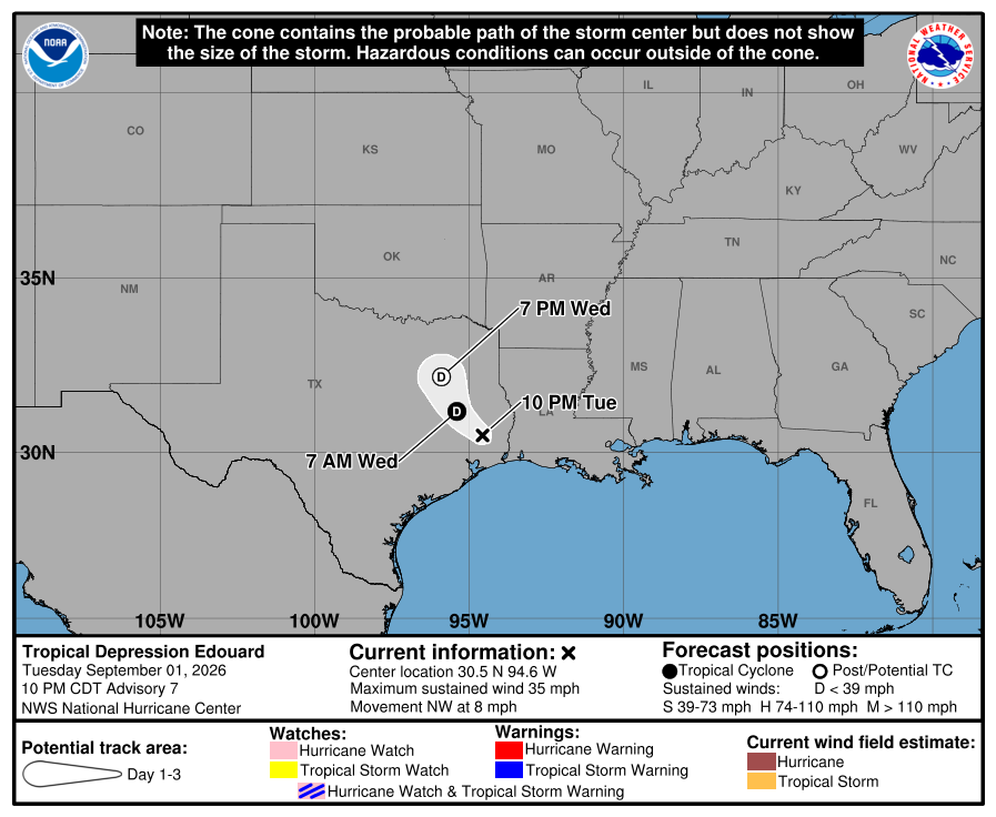
The tropical depression system was last addressed in a final advisory by the National Hurricane Center at 10 p.m. Tuesday. Edouard was previously a tropical storm but has since weakened and devolved to a tropical depression with sustained winds of 35 mph. Edouard after first crossing the Gulf of Mexico, traveled through Louisiana and is advancing to Texas. Tropical Depression Edouard is 40 miles northwest of Beaumont, Texas and 50 miles south-southeast of Lufkin, Texas. The system, with maximum sustained winds of 35 mph, is moving to the northwest at 8 mph.
“… the center of Edouard will continue moving inland over southeastern and eastern Texas through Wednesday,” forecasters noted. They also said “Continued weakening is expected during the next day or so, and Edouard is forecast to weaken to a tropical depression tonight and dissipate by Wednesday night.”
Yesterday (Monday)
The National Hurricane Center issued the first advisory for a potential tropical cyclone at 10 am yesterday (Monday).
The system changed into a tropical depression and was named Tropical Storm Edouard before it progressed to a tropical storm with sustained winds of 40 mph. Yesterday’s 7 p.m. report was the first to confirm the system’s new name.
Changes with this advisory
The Tropical Storm Warning has been discontinued along the Texas ad Louisiana coasts.
Hazards affecting land
Wind. Wind gusts to tropical-storm force may continue near the center of Edouard for the next several hours.
Rainfall. Edouard is expected to produce rainfall totals of 3 to 7 inches with maximum totals up to 12 inches for parts of the Upper Texas Coast inland through east-central Texas, with potential for 2 to 4 inches in far southwest Louisiana. This rainfall is likely to produce flash flooding, especially in low-lying and urban areas. Significant flash flooding is possible. River flooding may also be possible.
For a complete forecast of rainfall associated with Edouard, please see the National Weather Service Storm Total Rainfall Graphic available at hurricanes.gov/graphics_at5.shtml?rainqpf and the Flash Flood Risk graphic at hurricanes.gov/graphics_at5.shtml?ero.
For a list of rainfall observations (and wind reports) associated with Edouard, see the companion storm summary at WBCSCCNS5 with the WMO header ACUS45 KWBC or at the following link: www.wpc.ncep.noaa.gov/discussions/nfdscc5.html.
Tornadoes. A tornado or two is possible through tonight across parts of southwest Louisiana and southeast Texas.
Source: National Hurricane Center